mail_outline sales@mediastorehouse.com
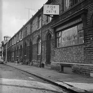
Saltaire DES01_01_0626Looking east along Titus Street, Saltaire, Shipley, Bradford, showing houses on the south side of the street with the Titus Street Fisheries at 39 Titus Street in the foreground
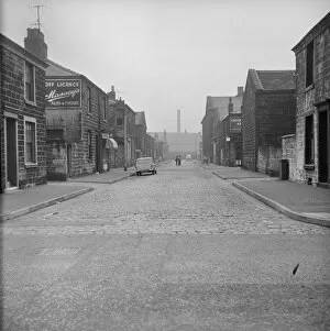
Burnley DES01_01_0567Looking south along Mary Street, Fulledge, Burnley, Lancashire, from Brunshaw Road (now Harry Potts Way) with the Cricketers Arms Beer House partially visible at the corner of Anne Street
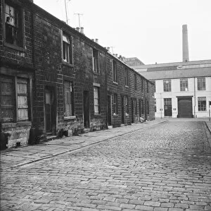
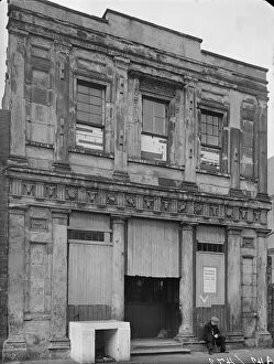
Burnley DES01_01_0539The terrace on the east side of Ashworth Street, Fulledge, Burnley, Lancashire, viewed from the junction of Richard Street showing boarded up and broken windows in some houses
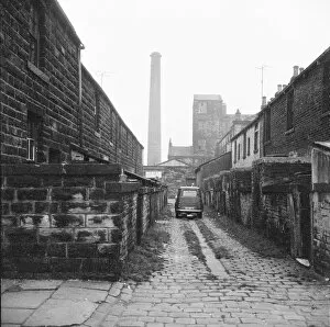
Burnley DES01_01_0538A car parked in the cobbled ginnel (alley) running between Milton Street and Tentre Street viewed from Richard Street, Burnley, Lancashire
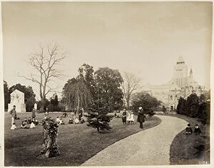
New Place Gardens, Stratford-upon-Avon BL05172A view from the west in New Place Gardens towards the Shakespeare Memorial Theatre, showing children and adults in the gardens with the Shakespeare Monument just visible on the left. 23 May 1884
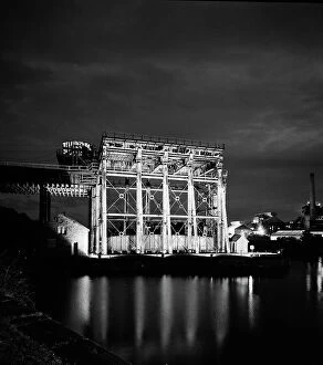
Anderton Boat Lift a99_09245ANDERTON BOAT LIFT, Cheshire. Floodlit night view from the west. The Boat Lift opened in 1875. It was built to transfer canal boats between the River Weaver Navigation and the Trent & Mersey Canal
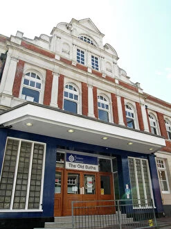
Woolwich Public Baths PLA01_03_0237The Old Baths, Bathway, Woolwich, Greenwich, Greater London. The entrance of The Old Baths performing arts centre of the University of Greenwich, originally the Woolwich Public Baths
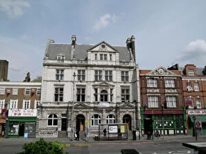
Hackney Baths PLA01_03_0096Kings Hall Leisure Centre, Lower Clapton Road, Lower Clapton, Hackney, Greater London. The front, Lower Clapton Road elevation of the Kings Hall Leisure Centre, originally Hackney Baths
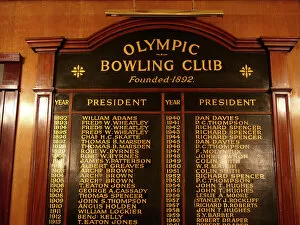
Honours board PLA01_02_009Olympic Bowling Club, Park Vale Road, Liverpool. The honours board at the Olympic Bowling Club, Liverpool. The club was founded in 1892
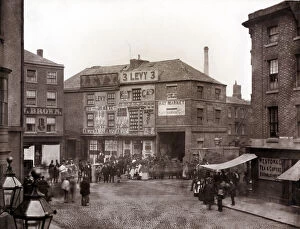
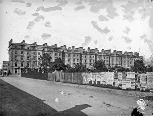
Leicester Haymarket OP32418HAYMARKET, CITY OF LEICESTER. A view from Humberstone Gate showing a crowd gathered at the junction of Church Gate, East Gates and Gallowtree Gate
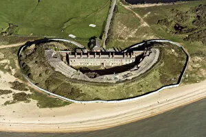
Fort Gilkicker 33939_006Fort Gilkicker, a semi circular, casemented coastal battery, Gosport, Hampshire, 2020. A Palmerston fort built in the 1860s to protect the anchorage at Spithead
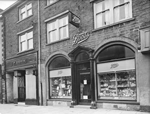
Boots in Skipton a58_00215SHEEP STREET, SKIPTON, CRAVEN, NORTH YORKSHIRE. Exterior view of the front elevation of Boots the Chemist on Sheep Street
Birmingham Canal Navigations Head Office BCN01_01_01Birmingham Canal Navigations Head Office, Paradise Street, Birmingham. Exterior view showing the front elevation in 1876. The gateways through this building gave access to the Old Wharf canal
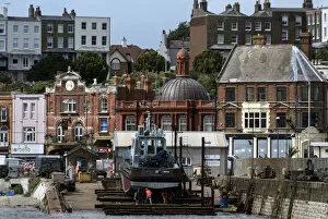
Ramsgate Harbour DP247129Ramsgate Harbour, Ramsgate, Thanet, Kent. General view of the harbour from the south, showing East Pier, where a boat is under repair on a slipway, and at the centre the Custom House of 1894-5
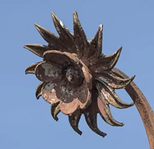
Iron flower DP235731Shrewsbury Flaxmill Maltings, Spring Gardens, Ditherington, Shrewsbury, Shropshire. Detail of an iron flower head, part of the ironwork of the coronet on top of the flaxmills Jubilee Tower
Centenary Mill Preston 28808_007Centenary Mill, Preston, Lancashire, 2015. Built in the 1890s. Named Centenary Mill to commemorate the foundation of John Horrocks first mill
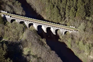
Kielder Railway Viaduct 28914_036Kielder, Northumberland. The disused Kielder Railway Viaduct, built in 1862 on the Border Counties Railway, Near Keilder, 2016
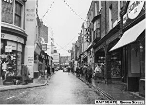
Ramsgate Queen Street PEN01_15_03_29429Queen Street, Ramsgate, Thanet, Kent. A street view of Queen Street, seen from the east near the junction with York Street, and looking west with a partial view of 51 Queen Street in the background
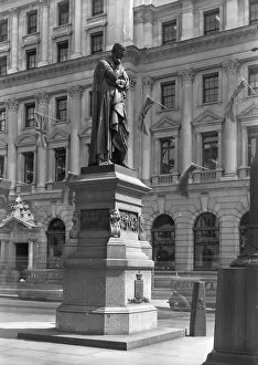
Baron Lawrence P_G03353_001BARON LAWRENCE STATUE, WATERLOO PLACE, CITY OF WESTMINSTER, GREATER LONDON
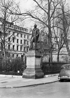
Lord Herbert of Lea P_G03423_001LORD HERBERT OF LEA STATUE, WATERLOO PLACE, CITY OF WESTMINSTER, GREATER LONDON. Sidney Herbert (1810-1861) was a close ally of Florence Nightingale
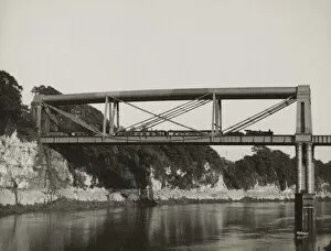
Chepstow Rail Bridge JRU01_01_190Chepstow Rail Bridge, Tidenham, Forest of Dean, Gloucestershire. The eastern section of Chepstow Rail Bridge, viewed from the north-west, with a train travelling across the bridge
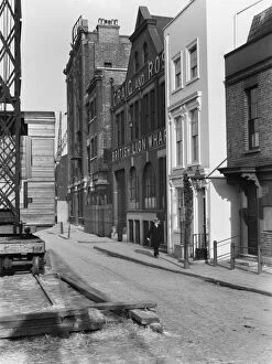
British Lion Wharf CXP01_01_040BANKSIDE, SOUTHWARK, GREATER LONDON. A view looking east along Bankside on the south side of the River Thames, showing a man walking past British Lion Wharf and Cardinals Wharf at number 49
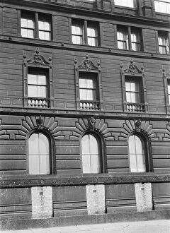
Watts Warehouse Manchester a42_01751WATTS WAREHOUSE, PORTLAND STREET, MANCHESTER. A detailed view of Watts Warehouse, now the Brittania Hotel, showing three bays of the basement to second floor
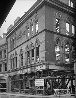
Union Street Ladywood Birmingham, 1941 a42_00461Midland House, 27 - 30 Union Street, Ladywood, Birmingham. Midland House, the premises of Chamberlain King & Jones Limited, at 27-30 Union Street and 12 Union Passage, showing bomb damage
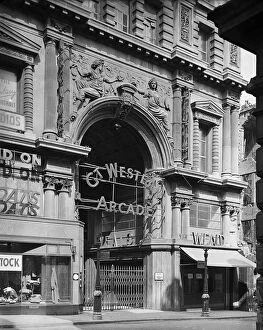
Great Western Arcade Birmingham, 1941 a42_00436GREAT WESTERN ARCADE, TEMPLE ROW, BIRMINGHAM. The entrance to the Great Western Arcade from Temple Row with two signs for ARP Shelters visible on lamp posts in the foreground
St Annes School Deritend a42_00472St Annes School, Alcester Street, Deritend, Digbeth, Birmingham. An old man seated outside St Annes School, Alcester Street
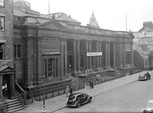
Royal Institute Museum a41_00129Royal Institute Museum, Albion Street, City of Kingston upon Hull. An exterior view of the Royal Institute Museum, built in 1852 by Cuthbert Brodrick and destroyed by the Hull blitz
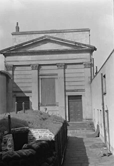
Trinity House Chapel, 1941 a41_00073Chapel at Hull Trinity House and Statue Outside East Front, Princes Dock Street, City of Kingston upon Hull. An exterior view of the east elevation of Trinity House Chapel
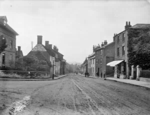
Farringdon CC97 / 02249London Street, Farringdon, Oxfordshire. General view down London Street with the Folly Inn in the forground. Photographed by Henry Taunt in 1905
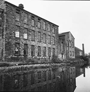
Airedale Mills Bingley DES01_01_0616Airedale Mills, Crossflatts, Bingley, Bradford, viewed across the Leeds and Liverpool Canal. Photographed by Eileen Deste between 1966 and 1974
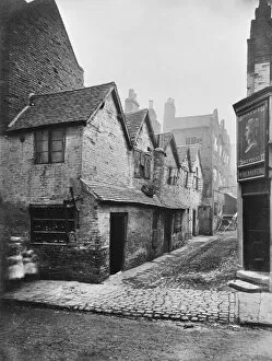
Old Birmingham BB65_04648A view from Steelhouse Lane, Birmingham looking into Queens Head Yard, the door to the Queens Head Tavern to the right. Glass plate negative photographed 1875
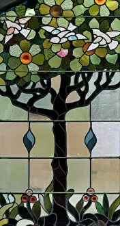
Tree with doves DP348860Royal Arcade, Back Of The Inns, Norwich, Norfolk. DDetail of stained-glass depicting doves and flowers in a tree, in the semi-circular top of the Royal Arcade's arcuated entrance, from the west
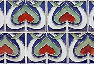
Tiled frieze DP348858Royal Arcade, Back Of The Inns, Norwich, Norfolk. Detail of a tiled frieze at first-floor level on the north side of the Royal Arcade, with abstract heart-shaped lotus-bud decorations, by G. J
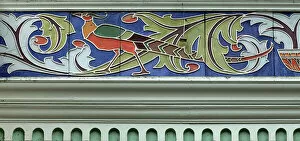
Peacock tiling DP348857Royal Arcade, Back Of The Inns, Norwich, Norfolk. Detail of a tiled frieze at first-floor level on the east side of the Royal Arcade, with decoration depicting a peacock amongst leaves, by G. J
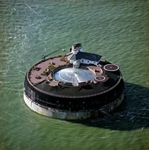
No Mans Land Fort EAC692690No Mans Land Fort, Solent, off Ryde, Isle of Wight, 2002
The Cedars OFH01_01_01_f09_02The Cedars, Ranelagh Road, Putney, Wandsworth, Greater London. The western terrace of The Cedars, seen from the south west
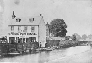
Feathers Boat House OFH01_01_01_f09_01Feathers Boat House, Wandsworth, Wandsworth, Greater London. The Feathers Boat House, also known as The Feathers Tavern, seen across the canal running parrallel to the River Wandle
Lower Richmond Road OFH01_01_01_f08_05Lower Richmond Road, Putney, Wandsworth, Greater London. The view looking east along Lower Richmond Road (then Windsor Street)
Red Lion OFH01_01_01_f08_04Lower Richmond Road, Putney, Wandsworth, Greater London. The view from outside St Mary's Church looking towards Lower Richmond Road (then Windsor Street)
Eight Bells OFH01_01_01_f08_03Lower Richmond Road, Putney, Wandsworth, Greater London. The view looking south east along Lower Richmond Road (formerly Windsor Street)
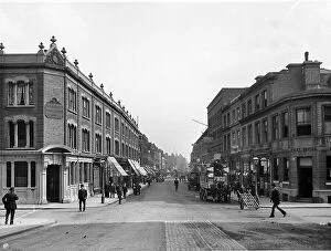
Putney High Street OFH01_01_01_f07_13PUTNEY HIGH STREET, PUTNEY, WANDSWORTH, GREATER LONDON. The view looking north along Putney High Street from the junctions of Norroy Road (right) and Disraeli Road (right)
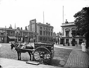
Railway Hotel OFH01_01_01_f07_11Railway Hotel, Upper Richmond Road, Putney, Wandsworth, Greater London. The crossroads of Putney High Street (foreground)
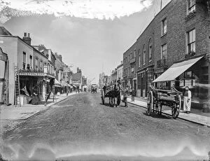
Putney High Street OFH01_01_01_f06_05PUTNEY HIGH STREET, PUTNEY, WANDSWORTH, GREATER LONDON. The view looking along Putney High Street towards the River Thames
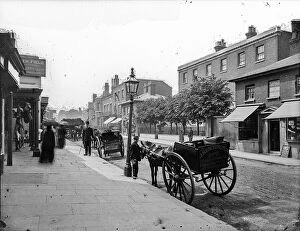
Putney High Street OFH01_01_01_f06_04PUTNEY HIGH STREET, PUTNEY, WANDSWORTH, GREATER LONDON. The view from the lower end of Putney High Street with Betts Butcher's shop at number 15 seen to the left. This image is reproduced as Fig
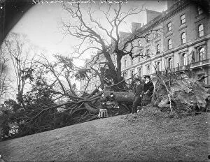
The Cedars OFH01_01_01_f09_03The Cedars, Ranelagh Road, Putney, Wandsworth, Greater London. A fallen tree in front of The Cedars. This photograph appears in William Fields's Photographs of Putney
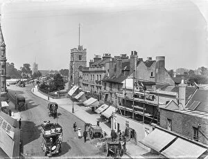
Putney OFH01_01_01_f05_16PUTNEY HIGH STREET, PUTNEY, WANDSWORTH, GREATER LONDON. An elevated view looking towards Putney Bridge from Putney High Street showing building work at number 15 with St Mary's Church Putney to
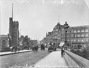
Putney High Street OFH01_01_01_f05_06PUTNEY HIGH STREET, PUTNEY, WANDSWORTH, GREATER LONDON. The view from Putney Bridge looking along Putney High Street with St Mary's Church in the left foreground
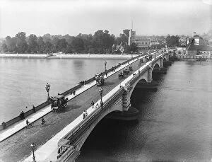
Putney Bridge OFH01_01_01_f03_19PUTNEY BRIDGE, PUTNEY, WANDSWORTH, GREATER LONDON. The view from the tower of St Mary's Church, Putney looking across the new Putney Bridge towards All Saints Church