mail_outline sales@mediastorehouse.com
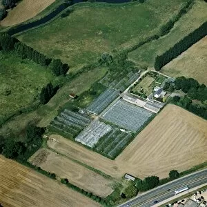
Market garden 24032_13Market garden near Sandy, Bedfordshire. Glasshouses near Sandy, some of which are derelict. Photographed in Auguest 2005
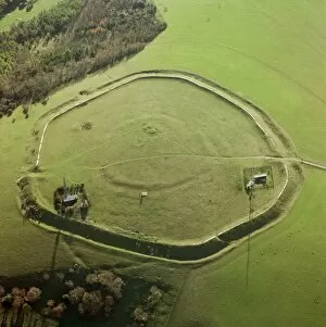
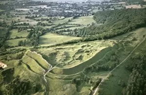
The Trundle 21025_07The Trundle, St Roches Hill, West Sussex. Inside the well-defined ramparts of an Iron Age hillfort lie the fainter remains of a Neolithic causewayed enclosure dating to perhaps 3700-3300 BC
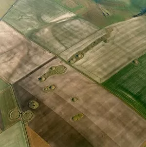
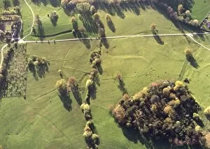
Normanton Down 18663_20Normanton Down, Wilsford cum Lake, Wiltshire. Aerial view showing the remains of barrows in the landscape around Normanton Down in Wiltshire
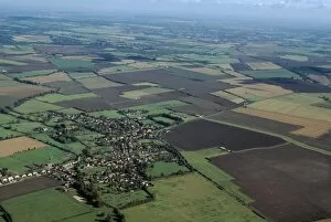
East Hanney 18512_16East Hanney, Oxfordshire. An aerial view of the village of East Hanney in Oxfordshire. Photographed in October 1999
Steventon Field 18389_12Steventon Field, Steventon, Oxfordshire. An aerial view of Steventon Field in Oxfordshire. Photographed in September 1999
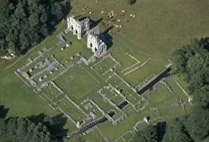
Roche Abbey 17292_28Roche Abbey, Maltby, South Yorkshire. An aerial view of the ruins from the south west. This Cistercian Abbey was founded in 1147
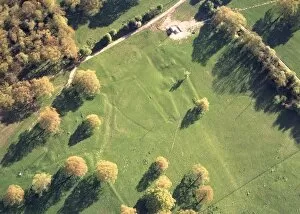
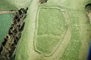
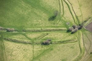
Earthworks at Hillend Cottages 18364_28Earthworks at Hillend Cottages, Eastnor, Herefordshire. An aerial view showing the earthworks at Hillend Cottages in Eastnor.Photographed in April 1999
Earthworks at Howlers Coppice 18364_22Earthworks at Howlers Coppice, Eastnor, Herefordshire. An aerial view showing archaeological earthworks at Howlers Coppice in Herefordshire. Photographed in April 1999
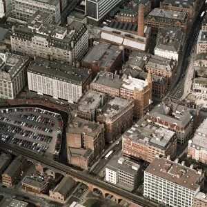
Manchester cotton warehouses 21161_02Whitworth Street/Princess Street, Manchester. This aerial photograph shows the cotton warehouse district of Manchester, most of which date from the late 19th and early 20th centuries
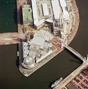
Lowry Centre 21156_01Lowry Centre, Salford Quays, Salford, Greater Manchester. An aerial view of the Lowry Centre. Named after the artist, L. S
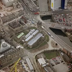
Manchester Cathedral 21152_08St Marys Cathedral, Manchester. Largely rebuilt in the 15th century as a collegiate church, it was raised to the rank of cathedral in 1847. Photographed in March 2001
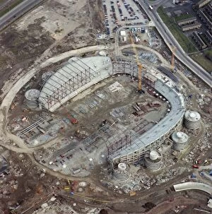
City of Manchester Stadium 21151_09City of Manchester Stadium, Manchester. An aerial view of the City of Manchester Stadium during the early stages of construction
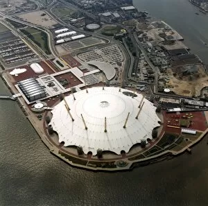
Millennium Dome 18795_22Millennium Dome, Greenwich, London. An aerial view of the Millennium Dome situated on a former gas works site by the River Thames
Painswick Camp JEH_22024_08bPainswick Camp, Painswick, Gloucestershire. This Iron Age hillfort (also known as Kimsbury Hillfort), is sited on the scarp of the Cotswolds overlooking the Severn valley
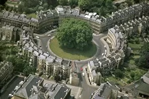
The Circus, Bath JEH_22026_35aThe Circus, Bath. The Circus was built by John Wood the elder in 1754-8. It was an original and innovative design, bending terraces of housing into tight curves
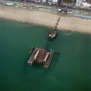
West Pier, Brighton 23448_020West Pier, Brighton, East Sussex. Aerial view of West Pier, taken after the storms and fire that badly damaged it in 1987 and 2003
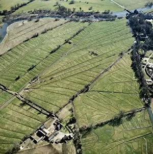
Watermeadows 24208_018Lower Farm, Britford, Wiltshire. At Britford, just south of Salisbury on the River Avon, a complex system of leats is used to channel water over the valley bottom in order to encourage early spring
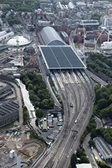
St Pancras Station 27537_006St Pancras Station, Camden, London. The flat-roofed extension built in 2007 provides capacity for the terminus of the Channel Tunnel Rail Link. Photographed in September 2012
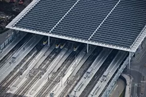
St Pancras Station 27537_008St Pancras Station, Camden, London. Detail of the flat-roofed extension built in 2007 to provide the terminus of the Channel Tunnel Rail Link. Photographed in September 2012
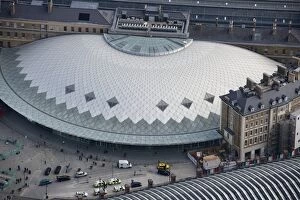
Kings Cross Station 27537_011Kings Cross Station, Camden, London. View showing the new concourse opened in March 2012. Photographed in September 2012
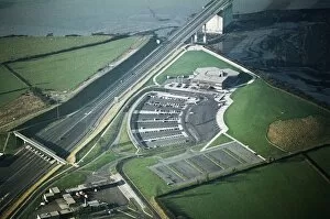
Aust Services JEH_22049_020Aust Services, Aust, South Gloucestershire. Large service station at the English end of the Severn Road Bridge, serving the former route of the M4 motorway
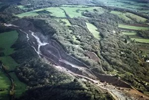
Road cutting JEH_22047_037Court Hill, Tickenham, Somerset. Construction works for the M5 motorway included the creation of these precipitous cuttings. Photographed in November 1970 by Jim Hancock
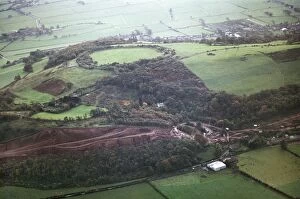
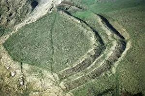
Cadbury Camp JEH_22046_070Cadbury Camp, Tickenham, Somerset. This Iron Age hillfort is thought by some to be the location of King Arthurs Camelot, although Cadbury Castle (South Cadbury) arguably has a stronger claim
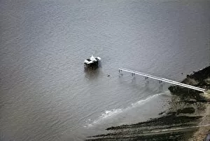
Clevedon Pier JEH_22046_058Clevedon Pier, North Somerset. This Victorian pier was originally opened in 1869. During stress testing in 1970 two of the spans collapsed
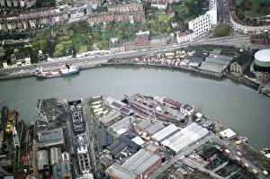
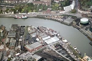
SS Great Britain JEH_22046_009Wapping Dockyard, Bristol. The SS Great Britain returned to the same dry dock that had been purpose-built for its construction by the Great Western Steamship Company between 1839-43
SS Great Britain JEH_22046_008Wapping Dockyard, Bristol. The SS Great Britain returned to the same dry dock that had been purpose-built for its construction by the Great Western Steamship Company between 1839-43
Cleeve Cloud JEH_22045_059Cleeve Cloud, Southam, Gloucestershire. Iron Age bivallate hillfort situated at the south-western edge of Cleeve common. Photographed in October 1970 by Jim Hancock
Dixton Hill JEH_22045_058Dixton Hill, Alderton, Gloucestershire. An Iron Age hillfort with a Norman motte and bailey castle superimposed at the south-east end. Photographed in October 1970 by Jim Hancock
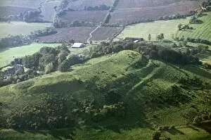
Conderton Camp JEH_22045_056Conderton Camp, Bredon Hill, Worcestershire. Photographed in October 1970 by Jim Hancock
Conderton Camp JEH_22045_028Conderton Camp, Bredon Hill, Worcestershire. Photographed in October 1970 by Jim Hancock
Kemerton Camp JEH_22045_024Kemerton Camp, Bredon Hill, Worcestershire. Photographed in October 1970 by Jim Hancock
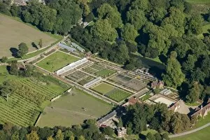
Audley End kitchen garden 29686_019Kitchen Garden, Audley End, Essex. This walled garden at Audley End has been revived to grow organic produce, some commercial and some of it for use by the English Heritage cafes
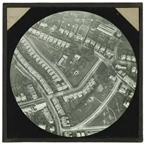
Catford House CVS01_01_060An aerial view of Catford House, Catford Hill, Lewisham and the surrounding streets. Balloon photograph taken from 1900 feet between 1885 and 1887
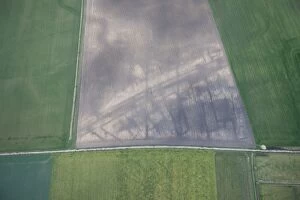
Roman settlement 27422_018March, Cambridgeshire. Soilmarks showing part of a Roman settlement comprising rectangular buildings and enclosures lining a road in a recently cultivated field
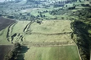
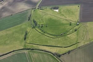
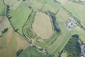
Stonea Camp 27422_009Stonea Camp, Cambridgeshire. Lying in the Fens near March, this is the lowest Iron Age hillfort in Britain. Detail of the earthwork remains of banks
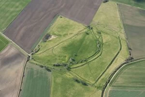
Stonea Camp 27422_005Stonea Camp, Cambridgeshire. Lying in the Fens near March, this is the lowest Iron Age hillfort in Britain. The earthwork remains of banks
Stonea Camp 27422_001Stonea Camp, Cambridgeshire. Lying in the Fens near March, this is the lowest Iron Age hillfort in Britain. The earthwork remains of banks
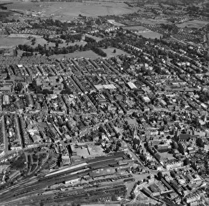
Cheltenham EAW136168Cheltenham, Gloucestershire. Photographed in August 1964. Aerofilms Collection
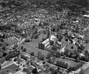
Salisbury EAW112528Salisbury, Wiltshire. The Cathedral and Cathedral Close. Photographed in May 1963. Aerofilms Collection
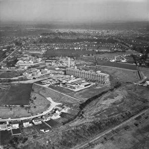
Princess Margaret Hospital EAW109066The Princess Margaret Hospital, Swindon (now demolished). Photographed in March 1963. Aerofilms Collection
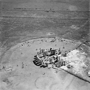
Restoring Stonehenge EAW072757Stonehenge, Wiltshire. Photographed in July 1958 with restoration works in progress. Aerofilms Collection
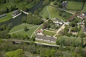
Bradford-on-Avon Tithe Barn 27463_045Bradford-on-Avon, Wiltshire. The medieval Tithe Barn with the Kennet and Avon Canal in the foreground
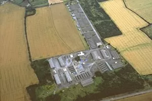
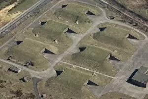
Greenham Common 27439_023GAMA Complex, Greenham Common, West Berkshire. Former USaF munitions storage bunkers at the Ground Launched Cruise Missile Alert and Maintenance Area
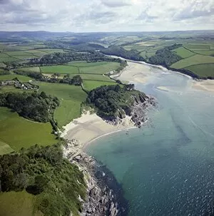
Rivermouth EAC0293046Mouth of the River Erme, Devon. Photographed in June 1975. Aerofilms Collection
Old Oswestry 28473_036Old Oswestry, Shropshire. Dramatic Iron Age hillfort photographed in August 2013
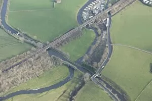
Transport routes 28351_020Leeds and Liverpool Canal and River Aire, North Yorkshire. At this point the river is crossed by an aqueduct and a railway viaduct, while the canal is crossed by road and rail bridges
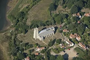
Blythburgh 27853_036Holy Trinity Church, Blythburgh, Suffolk. The " Cathedral of the Marshes" photographed in September 2013
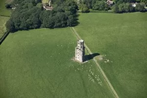
Horton Tower 27564_038Horton Tower, Dorset. An 18th century brick-built observatory