mail_outline sales@mediastorehouse.com
Choose a picture from our Images Dated 17th June 2021 Collection for your Wall Art and Photo Gifts
36 items
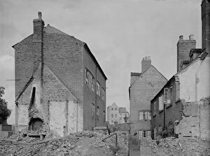
Little Park Street Coventry, 1941 a42_00353Court 16, Little Park Street, Coventry. The houses of Court 16 at the east side of Little Park Street showing damage caused by air raids
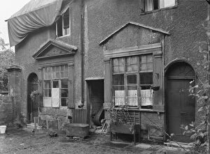
Little Park Street Coventry, 1941 a42_00356Court 20, Little Park Street, Coventry. The exterior of numbers 5 and 6, Court 20, accessed between 92 and 93 Little Park Street, showing the roof covered by tarpaulin
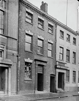
St Pauls Square Birmingham aa42_0012338 St Pauls Square, Jewellery Quarter, Birmingham. The exterior of 38 St Pauls Square, the premises of Martin & Company, Brassfounders and Woodworkers, photographed in 1941
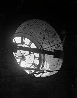
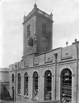
Clock dial a42_00120St Pauls Church, St Pauls Square, Jewellery Quarter, Birmingham. The clock dial of St Pauls Church viewed from within the tower. Photographed in 1941
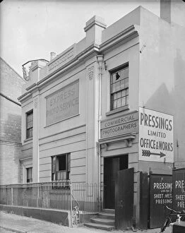
Cow Lane Coventry, 1941 a42_00357Baker Billing and Crows Charity School, Cow Lane, Coventry. The front elevation of Baker, Billing and Crows Charity School on Cow Lane showing the entrance to Pressings Limited Cow Lane Works
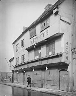
Much Park Street Coventry, 1941 a42_003628 - 10 Much Park Street, Coventry. Exterior view showing a policeman walking past the front elevation of 8-10 Much Park Street, premises of C. G. Hewitt
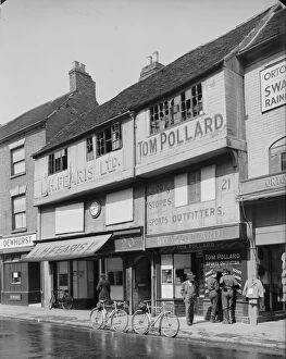
Jordan Well Coventry, 1941 a42_0033920 - 21 Jordan Well, Coventry. The exterior of 20 and 21 Jordan Well, premises of L H Fearis Ltd. and Tom Pollard, showing damage to the upper storey windows
New Street Coventry, 1941 a42_00327New Street, Coventry. The exterior of 30 New Street with a woman standing in the doorway of the house holding a baby and the windows boarded as a result of bomb damage
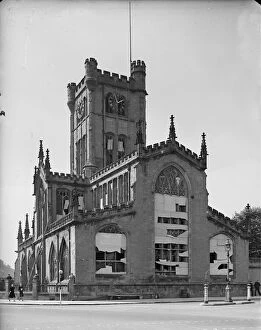
St Johns Church, Deritend, 1942 a42_00201St Johns Church, High Street Deritend, Deritend, Birmingham. The south elevation and tower of St Johns Church showing bomb damage. This building of 1735 replaced an earlier chapel of 1380
St Clements Church a42_00038St Clements Church, CHAPELTOWN ROAD, SHEEPSCAR, Leeds. An interior view of the nave and apsidal chancel of St Clements Church, seen from the west end and demolished circa 1976
Manchester Cathedral, 1942 a42_00073CATHEDRAL CHURCH OF ST MARY, FENNEL STREET, MANCHESTER. An interior view of Manchester Cathedral, or St Marys Cathedral Church, showing the east end of the nave
Cook Street Coventry, 1941 a42_0037611 - 12 Cook Street, Coventry. Exterior view of the front elevation of 11-12 Cook Street, showing bomb damage. Coventry City centre was devastated by air raids in 1940
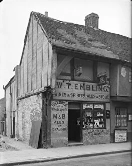
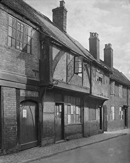
Spon Street Coventry, 1941 a42_00365Spon Street, Coventry. The exterior of 54 Spon Street, premises of William Thomas Embling, off-licence
Greyfriars Lane Coventry, 1941 a42_0035827 - 28 Greyfriars Lane, Coventry. The front elevation of 27 and 28 Greyfriars Lane and the access to Court 6, showing evidence of bomb damage
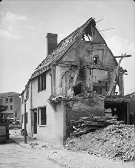
Cook Street Coventry, 1941 a42_00375COOK STREET, COVENTRY. Exterior view showing bomb damaged cottages on Cook Street
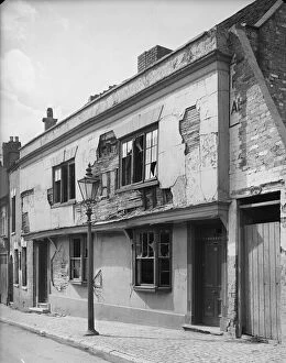
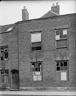
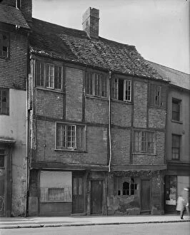
Little Park Street Coventry, 1941 a42_00351Little Park Street, Coventry. The exterior of 92 Little Park Street showing bomb damage to the facade and notices relating to rationing and air raids posted to the boards covering the broken windows
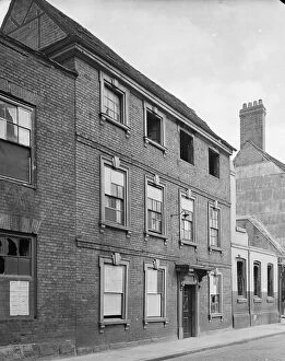
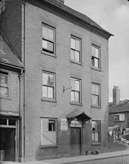
Little Park Street Coventry, 1941 a42_00350Little Park Street, Coventry. The exterior of 91 Little Park Street showing bomb damage to windows and the remains of 90 Little Park Street to the right of frame
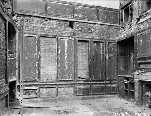
Little Park Street Coventry, 1941 a42_00349Little Park Street, Coventry. The interior of 90 Little Park Street showing bomb damage. Coventry City centre was devastated by air raids in November 1940
Little Park Street Coventry, 1941 a42_00347Little Park Street, Coventry. The exterior of 83 Little Park Street showing damage caused during air raids. Coventry City centre was devastated by air raids in November 1940
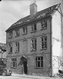
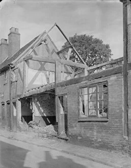
Kirby House Coventry, 1941 a42_00346Kirby House, Little Park Street, Coventry. The rear elevation of Kirby House at 16 Little Park Street showing evidence of bomb damage
Gosford Street Coventry, 1941 a42_003386 - 7 Gosford Street, Coventry. The exterior of shop premises at 6 and 7 Gosford Street showing foodstuffs displayed outside number 7 and a tarpaulin covering damage to the roof of number 6
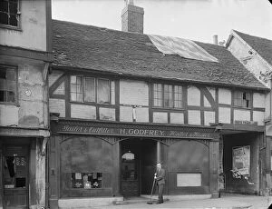
Gosford Street Coventry, 1941 a42_00335Gosford Street, Coventry. The bomb damaged premises of H Godfrey, Tailor and Outfitter, at 112 Gosford Street showing a man sweeping the pavement at the front of the shop
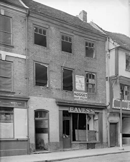
Mermaid Inn, 1941 a42_00333Mermaid Inn, Gosford Street, Coventry. The premises of Eavess at 110 Gosford Street, adjacent to the Mermaid Inn showing bomb damage
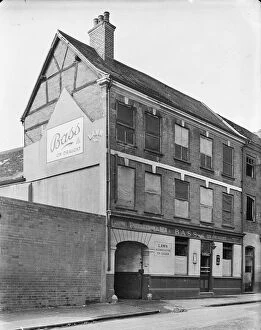
Mermaid Inn, 1941 a42_00332Mermaid Inn, Gosford Street, Coventry. The Mermaid Inn at 109 Gosford Street. The windows of the public house are boarded, probably as a result of bomb damage
Kirby House Coventry, 1941 a42_00343Kirby House, Little Park Street, Coventry. The front elevation of Kirby House at 16 Little Park Street showing evidence of windows broken during air raids
New Street Coventry, 1941 a42_00326New Street, Coventry. The remains of 29 New Street, showing probable bomb damage. Coventry City centre was devastated by air raids in November 1940
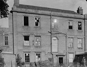
New Street Coventry, 1941 a42_00325New Street, Coventry. The exterior of 22 New Street. The houses appears to be abandoned, probably following damage during the Coventry Blitz
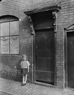
New Street Coventry, 1941 a42_00324New Street, Coventry. A young girl standing on the pavement outside the front door of 13 New Street. The window beside the doorway appears to be boarded, probably as a result of bomb damage
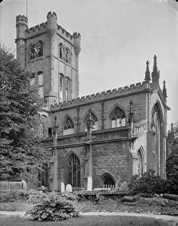
St Johns Bablake, 1941 a42_00321St John the Baptists Church, Fleet Street, Bablake, Coventry. St John the Baptists Church viewed from the south east showing windows boarded as a result of bomb damage
Gosford Street Coventry, 1941 a42_0033035 - 36 Gosford Street, Coventry. The exterior of 35 and 36 Gosford Street. The building appears to show evidence of bomb damage
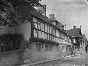
Bablake School, 1941 a42_00294BABLAKE SCHOOL, HILL STREET, COVENTRY. Bablake School viewed from Hill Street showing a man carrying out repair work to one of the dormer windows and Bonds Hospital in the background
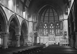
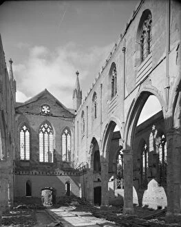
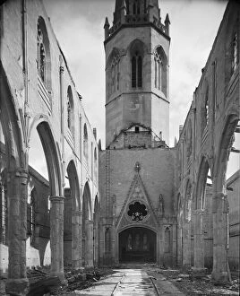
Christ Church Coventry 1941 a42_00288Christ Church, New Union Street, Coventry. A view looking north west across the nave and north aisle in Christ Church, showing the results of bomb damage
Christ Church Coventry 1941 a42_00285Christ Church, New Union Street, Coventry. A view looking east along the nave of Christ Church showing the results of bomb damage
St Johns Bablake, 1941 a42_00320St John the Baptists Church, Fleet Street, Bablake, Coventry. The east end of St John the Baptists Church viewed from Corporation Street showing windows boarded as a result of bomb damage
St Johns Bablake, 1941 a42_00318St John the Baptists Church, Fleet Street, Bablake, Coventry. The west end of St John the Baptists Church viewed from the north west showing windows boarded as a result of bomb damage
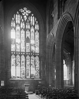
St Johns Bablake, 1941 a42_00316St John the Baptists Church, Fleet Street, Bablake, Coventry. A view looking along the nave towards the font in St John the Baptists Church showing damage to the west window