mail_outline sales@mediastorehouse.com
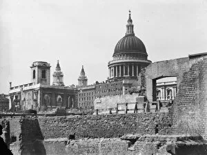
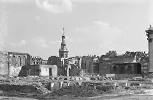
St Pauls CXP01_01_087St Pauls Cathedral, St Pauls Churchyard, City of London. A view looking north-west across a bomb damaged landscape towards St Pauls Cathedral with St Nicholas Cole Abbey on the left of
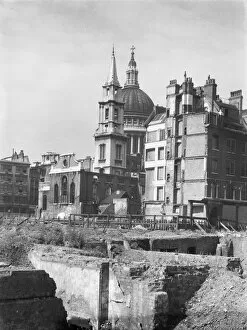
St Pauls CXP01_01_086St Pauls Cathedral, St Pauls Churchyard, City of London. A view looking south-west across a bomb damaged landscape towards the Church of St Verdast-alias-Foster with St Pauls Cathedral beyond
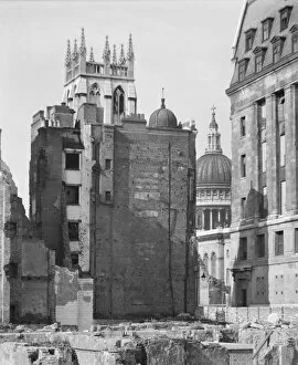
St Pauls CXP01_01_085St Pauls Cathedral, St Pauls Churchyard, City of London. A view from the north-east showing the dome of St Pauls Cathedral through a gap between buildings
St Pauls CXP01_01_084St Pauls Cathedral, St Pauls Churchyard, City of London. A view looking south-west across a bomb damaged landscape towards the Church of St Verdast-alias-Foster with St Pauls Cathedral beyond
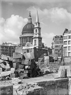
St Mary-le-Bow CXP01_01_083St Mary-le-Bow Church, Cheapside, City of London. A view looking south-east across a bomb damaged landscape towards St Mary-le-Bow Church, with a corner of Goldsmiths Hall just visible on the right
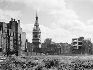
St Mary-le-Bow CXP01_01_081St Mary-le-Bow Church, Cheapside, City of London. A view looking east across a bomb damaged landscape towards St Mary-le-Bow Church
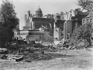
Demolition at Whitehall Gardens CXP01_01_091PEMBROKE HOUSE, WHITEHALL GARDENS, WHITEHALL, CITY OF WESTMINSTER, GREATER LONDON. A view of the remains of Pembroke House at 7 Whitehall Gardens seen during demolition
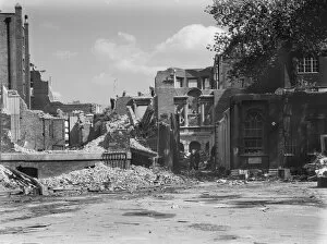
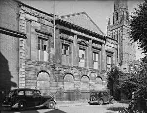
Demolition at Whitehall Gardens CXP01_01_079WHITEHALL GARDENS, WHITEHALL, CITY OF WESTMINSTER, GREATER LONDON. A view of the remains of Whitehall Gardens seen during demolition with a cupola on the War Office building visible in
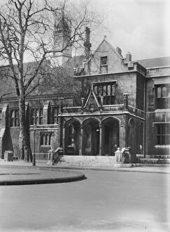
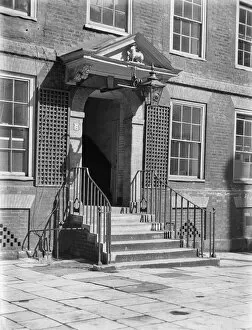
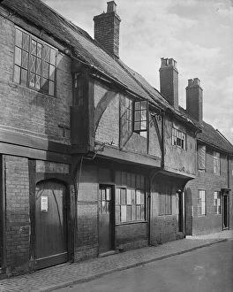
Grays Inn CXP01_01_056GRAYs INN, CAMDEN, GREATER LONDON. A view of Grays Inn from south-east in South Square, showing the arched entrance porch and hall to the left
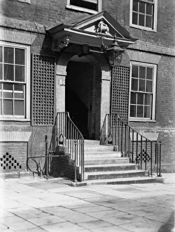
Lamb Building, Temple CXP01_01_044LAMB BUILDING, CHURCH COURT, TEMPLE, CITY OF LONDON. The entrance to Lamb Building with a carved model of the Lamb of God in the pediment over the door
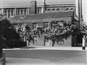
Hammersmith CXP01_01_04824-26 Queen Street, Hammersmith, Greater London. A view from the south-east showing 24-26 Queen Street with St Pauls Church behind
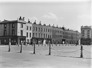
Cumberland Market CXP01_01_071CUMBERLAND MARKET, REGENTS PARK, CAMDEN, GREATER LONDON. A view looking south-east across Cumberland Market towards a terrace of houses on the east side of the square, south of Edward Street
Lamb Building, Temple CXP01_01_067LAMB BUILDING, CHURCH COURT, TEMPLE, CITY OF LONDON. The entrance to Lamb Building with a carved model of the Lamb of God in the pediment over the door
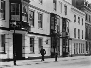
George Hotel Portsmouth CXP01_01_052GEORGE HOTEL, HIGH STREET, PORTSMOUTH. The front of the George Hotel seen from the north-east with a man walking past the entrance
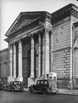
Market Hall Wolverhampton, 1942 a42_03222Market Hall, North Street, Wolverhampton. The west portico of the Market Hall in North Street. The Market Hall opened in 1853
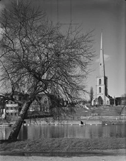
St Andrews Worcester, 1942 a42_03478St Andrews Church, Deansway, Worcester viewed across the River Severn in April 1942. The medieval church of St Andrew was demolished in 1948/49 as it was believed to be structurally unstable
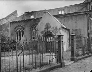
St Benedicts Norwich, 1942 a42_03731St Benedicts Church, St Benedicts Street, Norwich, Norfolk. The north elevation of St Benedicts Church showing bomb damage following an air raid in January 1942
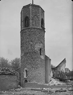
St Benedicts Norwich, 1942 a42_03730St Benedicts Church, St Benedicts Street, Norwich, Norfolk. The surviving tower of St Benedicts Church following an air raid in January 1942 which destroyed the body of the church
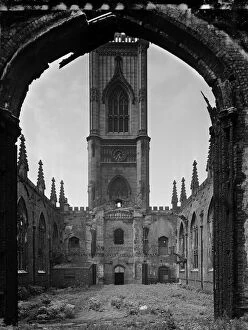
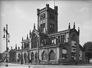
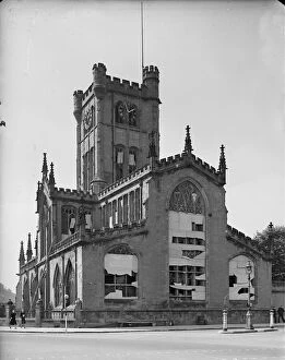
St Lukes Church Liverpool a63_07033ST LUKES CHURCH, LEECE STREET, LIVERPOOL. A view from beneath the chancel arch looking west towards the tower in the bombed out ruins of St Lukes Church
County Hall Coventry, 1941 a42_00527County Hall, Cuckoo Lane, Coventry. County Hall viewed from Cuckoo Lane with the tower of Holy Trinity Church in the background. The former courthouse at County Hall opened in 1783
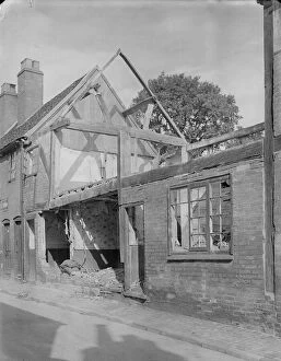
Cook Street Coventry, 1941 a42_0037611 - 12 Cook Street, Coventry. Exterior view of the front elevation of 11-12 Cook Street, showing bomb damage. Coventry City centre was devastated by air raids in 1940
Greyfriars Lane Coventry, 1941 a42_0035827 - 28 Greyfriars Lane, Coventry. The front elevation of 27 and 28 Greyfriars Lane and the access to Court 6, showing evidence of bomb damage
Cook Street Coventry, 1941 a42_00375COOK STREET, COVENTRY. Exterior view showing bomb damaged cottages on Cook Street
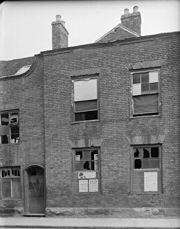
Little Park Street Coventry, 1941 a42_00351Little Park Street, Coventry. The exterior of 92 Little Park Street showing bomb damage to the facade and notices relating to rationing and air raids posted to the boards covering the broken windows
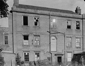
Little Park Street Coventry, 1941 a42_00350Little Park Street, Coventry. The exterior of 91 Little Park Street showing bomb damage to windows and the remains of 90 Little Park Street to the right of frame
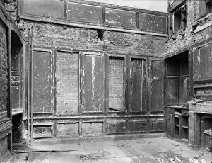
Little Park Street Coventry, 1941 a42_00349Little Park Street, Coventry. The interior of 90 Little Park Street showing bomb damage. Coventry City centre was devastated by air raids in November 1940
Little Park Street Coventry, 1941 a42_00347Little Park Street, Coventry. The exterior of 83 Little Park Street showing damage caused during air raids. Coventry City centre was devastated by air raids in November 1940
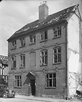
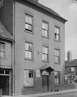
Kirby House Coventry, 1941 a42_00346Kirby House, Little Park Street, Coventry. The rear elevation of Kirby House at 16 Little Park Street showing evidence of bomb damage
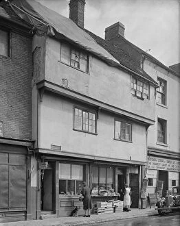
Gosford Street Coventry, 1941 a42_003386 - 7 Gosford Street, Coventry. The exterior of shop premises at 6 and 7 Gosford Street showing foodstuffs displayed outside number 7 and a tarpaulin covering damage to the roof of number 6
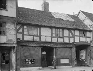
Gosford Street Coventry, 1941 a42_00335Gosford Street, Coventry. The bomb damaged premises of H Godfrey, Tailor and Outfitter, at 112 Gosford Street showing a man sweeping the pavement at the front of the shop
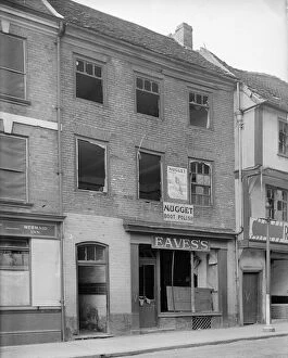
Mermaid Inn, 1941 a42_00333Mermaid Inn, Gosford Street, Coventry. The premises of Eavess at 110 Gosford Street, adjacent to the Mermaid Inn showing bomb damage
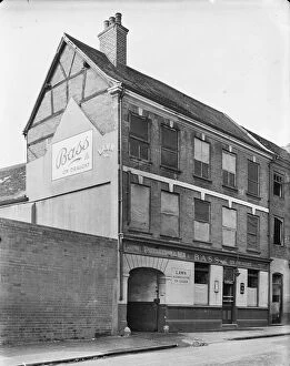
Mermaid Inn, 1941 a42_00332Mermaid Inn, Gosford Street, Coventry. The Mermaid Inn at 109 Gosford Street. The windows of the public house are boarded, probably as a result of bomb damage
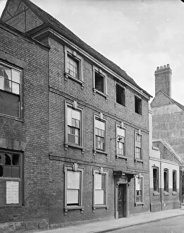
Kirby House Coventry, 1941 a42_00343Kirby House, Little Park Street, Coventry. The front elevation of Kirby House at 16 Little Park Street showing evidence of windows broken during air raids
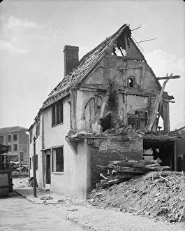
New Street Coventry, 1941 a42_00326New Street, Coventry. The remains of 29 New Street, showing probable bomb damage. Coventry City centre was devastated by air raids in November 1940
New Street Coventry, 1941 a42_00325New Street, Coventry. The exterior of 22 New Street. The houses appears to be abandoned, probably following damage during the Coventry Blitz
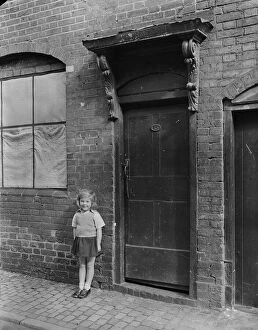
New Street Coventry, 1941 a42_00324New Street, Coventry. A young girl standing on the pavement outside the front door of 13 New Street. The window beside the doorway appears to be boarded, probably as a result of bomb damage
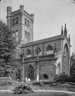
St Johns Bablake, 1941 a42_00321St John the Baptists Church, Fleet Street, Bablake, Coventry. St John the Baptists Church viewed from the south east showing windows boarded as a result of bomb damage
Gosford Street Coventry, 1941 a42_0033035 - 36 Gosford Street, Coventry. The exterior of 35 and 36 Gosford Street. The building appears to show evidence of bomb damage
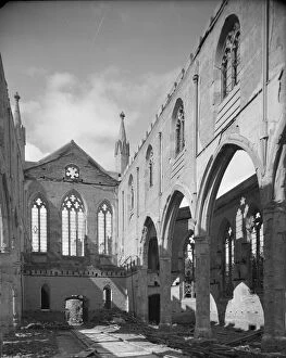
Christ Church Coventry 1941 a42_00288Christ Church, New Union Street, Coventry. A view looking north west across the nave and north aisle in Christ Church, showing the results of bomb damage
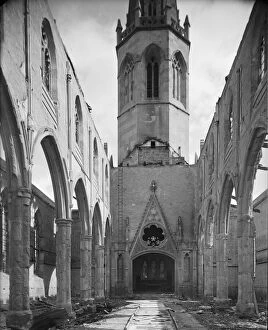
Christ Church Coventry 1941 a42_00285Christ Church, New Union Street, Coventry. A view looking east along the nave of Christ Church showing the results of bomb damage
St Johns Bablake, 1941 a42_00320St John the Baptists Church, Fleet Street, Bablake, Coventry. The east end of St John the Baptists Church viewed from Corporation Street showing windows boarded as a result of bomb damage
St Johns Bablake, 1941 a42_00318St John the Baptists Church, Fleet Street, Bablake, Coventry. The west end of St John the Baptists Church viewed from the north west showing windows boarded as a result of bomb damage
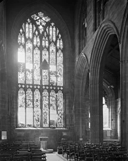
St Johns Bablake, 1941 a42_00316St John the Baptists Church, Fleet Street, Bablake, Coventry. A view looking along the nave towards the font in St John the Baptists Church showing damage to the west window
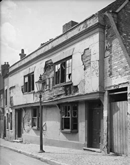
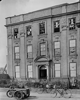
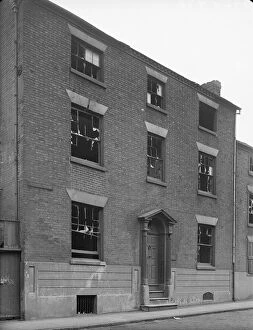
Chapel House Deritend, 1941 a42_00470Chapel House, Chapel House Street, Deritend, Digbeth, Birmingham. The exterior of Chapel House showing broken windows, probably a result of bomb damage
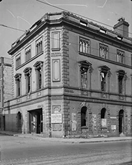
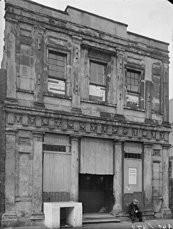
Horsefair Birmingham, 1941 a42_00441Colonial Buildings, 7 Horsefair, Ladywood, Birmingham. The premises of the Birmingham Tube and Fittings Company Limited on the corner of Horsefair and Windmill Street
St Annes School Deritend a42_00472St Annes School, Alcester Street, Deritend, Digbeth, Birmingham. An old man seated outside St Annes School, Alcester Street
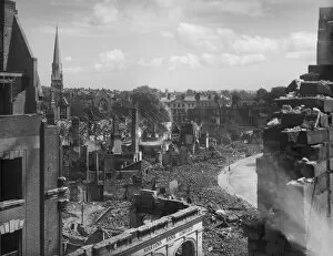
Bomb damage, Exeter BB42_00707Exeter, Devon. Bomb damage on the north side of Bedford Circus looking towards Southernhay and the spire of Southernhay Congregational Church
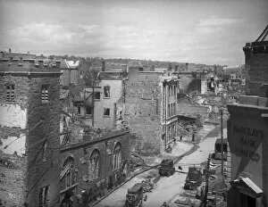
Bomb damage, Exeter BB42_00706Exeter, Devon. A view looking east along the High Street from the roof of Dellers Cafe showing the burnt out Church of St Lawrence in the foreground