mail_outline sales@mediastorehouse.com
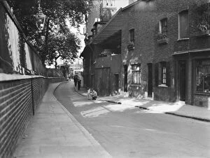
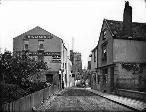
Collingwood Street, Blackfriars CXP01_01_058COLLINGWOOD STREET, BLACKFRIARS, SOUTHWARK, GREATER LONDON. A view looking north-east along Collingwood Street, showing figures walking past weatherboarded cottages on the east side of the street
Kings Lynn DP217305Nelson Street, Kings Lynn, Kings Lynn And West Norfolk. Nelson Street, looking north from adjacent to number 10, August 2017
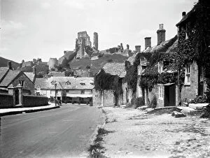
Corfe Castle MCF01_02_0951CORFE CASTLE, PURBECK, DORSET. Looking along East Street towards the Greyhound Hotel with the ruins of Corfe Castle on the hill beyond
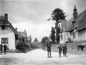
Wootton Rivers MCF01_02_0674Wootton Rivers, Wiltshire, Wiltshire. A view looking north along the main street through Wootton Rivers, showing The Royal Oak Inn on the right of the foreground
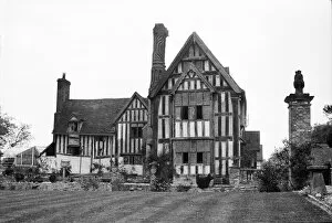
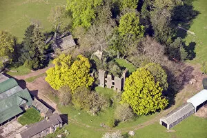
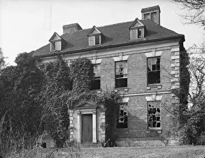
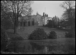
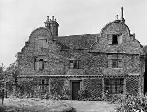
Huddington Court BB48_00220HUDDINGTON COURT, HUDDINGTON, WYCHAVON, WORCESTERSHIRE. Exterior view of Huddington Court and gardens. Exterior view of Huddington Court and gardens
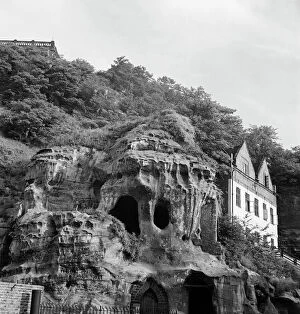
Castle Rock a081306Brewhouse Yard Museum Of Nottingham Life, Castle Boulevard, Nottingham. The base of Castle Rock, showing the caves above the entrance to Mortimers Hole, with Rock Cottage beyond
Olantigh Towers 33247_012Stable block to Olantigh Towers, Kent, 2016
Mersham-le-Hatch 33247_024Mersham-le-Hatch walled garden, stables and house, Kent, 2016
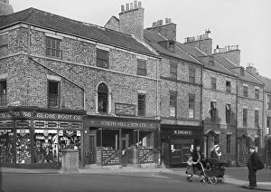
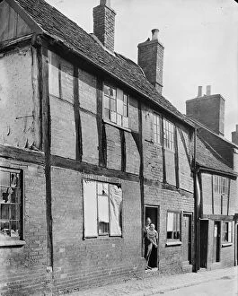
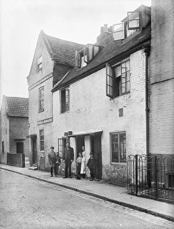
North Shields shops a49_0723397-100 Howard Street, North Shields, North Tyneside, 1949. Exterior view from the north-west of 97-100 Howard Street
Urishay 33225_046Urishay, Peterchurch, Herefordshire. A motte castle and the ruins of a chapel and post-medieval house, 2016
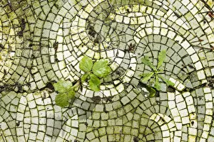
Decaying mosaic pavement DP168226Doxford House, Warden Law Lane, New Silksworth, Sunderland, Tyne & Wear. Detail of the mosaic floor of the conservatory area on the east side of the derelict house
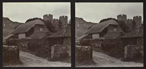
Amberley Castle ZEH01_01_15AMBERLEY CASTLE, AMBERLEY, HORSHAM, WEST SUSSEX. Stereoscopic view from the south-west looking up towards the gatehouse and curtain wall of Amberley Castle
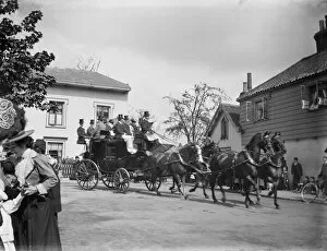
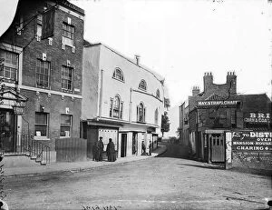
Coach and four CXP01_01_153A horse-drawn coach driving past a group of cottages in an unidentified area of London, with spectators watching. The people on top of the coach may be part of a coaching club meet driving from Hyde
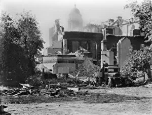
Demolition at Whitehall Gardens CXP01_01_075WHITEHALL GARDENS, WHITEHALL, CITY OF WESTMINSTER, GREATER LONDON. A view of the remains of Whitehall Gardens seen during demolition with a cupola on the War Office building visible in
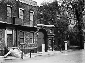
Whitehall Gardens 1930s CXP01_01_043WHITEHALL GARDENS, WHITEHALL, CITY OF WESTMINSTER, GREATER LONDON. The front of Malmesbury House and the entrance lodge to Pembroke House at 7 Whitehall Gardens seen from the north-west
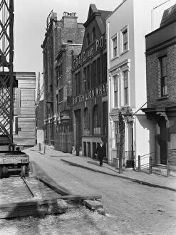
British Lion Wharf CXP01_01_040BANKSIDE, SOUTHWARK, GREATER LONDON. A view looking east along Bankside on the south side of the River Thames, showing a man walking past British Lion Wharf and Cardinals Wharf at number 49
The Rookery Sutton Coldfield, 1942 a42_03385The Rookery, Lichfield Road, Sutton Coldfield, Birmingham. The derelict east front of The Rookery. Once described as " The greatest ornament and addition to the town of Sutton"
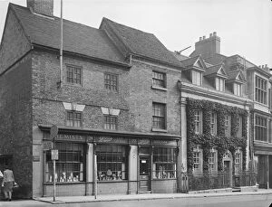
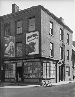
High Street Sutton Coldfield, 1942 a42_03367High Street, Sutton Coldfield, Birmingham. The front elevation of 20-24 High Street, including the premises of Boots the Chemists
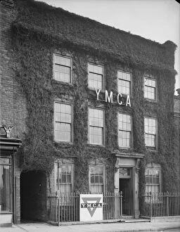
YMCA Sutton Coldfield, 1942 a42_03363Y M C A Hostel, High Street, Sutton Coldfield, Birmingham. The front elevation of the YMCA Hostel at 2 High Street, photographed in 1942
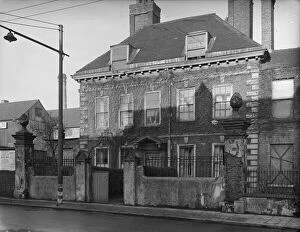
Bilston Street, Wolverhampton a42_03227Bilston Street, Wolverhampton. The front elevation of 19 Bilston Street This building probably started life as a private town house in the late 17th or 18th century
New Street Worcester, 1942 a42_03571New Street, Worcester. The exterior of 4 Corn Market and 30 New Street, part of King Charles House, viewed from Corn Market
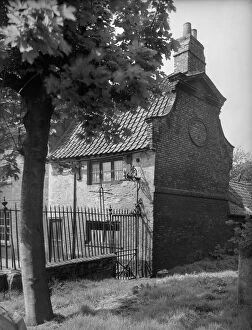
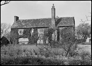
The Exorcists House Kings Lynn, 1942 a42_03875The Exorcists House, Chapel Lane, Kings Lynn, West Norfolk. The Exorcists House viewed from the churchyard of St Nicholas Chapel
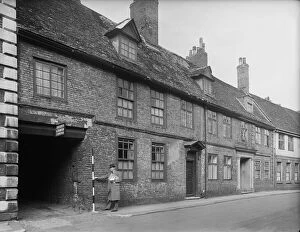
Burnham House Kings Lynn, 1942 a42_03803Burnham House, 11 - 13 Nelson Street, Kings Lynn, Norfolk. A man holding a ranging pole beside the carriage entrance of Burnham House at 11-13 Nelson Street
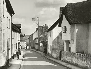
Chagford DIX02_01_033Lower Street, Chagford, Chagford, West Devon. The view looking north west along Lower Street with Bishops House in the right foreground, 1930s
Barlow Hall a42_01730BARLOW HALL, BARLOW HALL ROAD, CHORLTON CUM HARDY, MANCHESTER. An exterior view of Barlow Hall, seen from the south-west in the grounds, with a moat in the foreground
Peel Hall Manchester a42_01959Peel Hall Manchester. An exterior view of Peel Hall, a farmhouse built in 1810 on the site of the former Peel Hall and demolished in 1975 Peel Hall was originally constructed by Sir John de Ardene
Little Park Street Coventry, 1941 a42_00356Court 20, Little Park Street, Coventry. The exterior of numbers 5 and 6, Court 20, accessed between 92 and 93 Little Park Street, showing the roof covered by tarpaulin
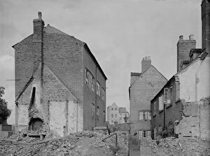
Little Park Street Coventry, 1941 a42_00353Court 16, Little Park Street, Coventry. The houses of Court 16 at the east side of Little Park Street showing damage caused by air raids
New Street Coventry, 1941 a42_00327New Street, Coventry. The exterior of 30 New Street with a woman standing in the doorway of the house holding a baby and the windows boarded as a result of bomb damage
St Annes Convent Deritend a42_00473St Annes Convent, Lowe Street, Deritend, Digbeth, Birmingham. The exterior of St Annes Convent viewed from the east showing the pre Victorian building
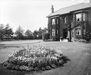
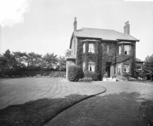
Sandycroft BL23602_003Sandycroft, Old Town Lane, Formby, Freshfield, Sefton, Merseyside. A circular flower bed in front of the house. The photograph was taken in 1916 for Sidney John Lister who lived at Sandycroft
Sandycroft BL23602_002Sandycroft, Old Town Lane, Formby, Freshfield, Sefton, Merseyside. The photograph was taken in 1916 for Sidney John Lister who lived at Sandycroft and worked for the Cunard Steamship Company
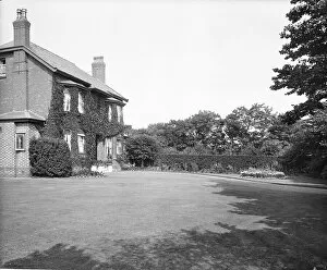
Sandycroft BL23602_001The front of the house. Sandycroft, Old Town Lane, Formby, Freshfield, Sefton, Merseyside. The photograph was taken in 1916 for Sidney John Lister who lived at Sandycroft
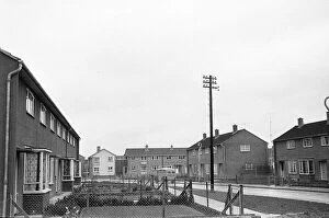
Housing estate GOM01_05_029_09Walsingham Road, Walcot East, Swindon, Wiltshire. A view looking north west along Walsingham Road with number 5 in the left foreground and houses at the entrance to Darnley Close in the background
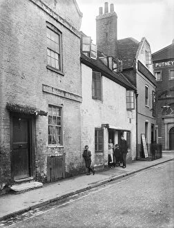
Albert Row OFH01_01_01_f08_09Albert Row, Putney, Wandsworth, Greater London. The seventeenth century cottages of Albert Row, with Albert Place in the background. These buildings stood approximately where Weimer Street now stands
Red Lion OFH01_01_01_f08_04Lower Richmond Road, Putney, Wandsworth, Greater London. The view from outside St Mary's Church looking towards Lower Richmond Road (then Windsor Street)
Eight Bells OFH01_01_01_f08_03Lower Richmond Road, Putney, Wandsworth, Greater London. The view looking south east along Lower Richmond Road (formerly Windsor Street)
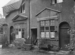
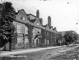
Fairfax House OFH01_01_01_f06_17FAIRFAX HOUSE, HIGH STREET, PUTNEY, WANDSWORTH, GREATER LONDON. The side and rear of Fairfax House seen from the yard
Fairfax House OFH01_01_01_f06_10FAIRFAX HOUSE, HIGH STREET, PUTNEY, WANDSWORTH, GREATER LONDON. Fairfax House, seen looking south east from Putney High Street with the stables immediately beyond the house
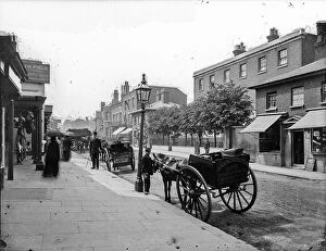
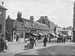
Putney High Street OFH01_01_01_f06_04PUTNEY HIGH STREET, PUTNEY, WANDSWORTH, GREATER LONDON. The view from the lower end of Putney High Street with Betts Butcher's shop at number 15 seen to the left. This image is reproduced as Fig
Brewhouse Lane OFH01_01_01_f09_11Brewhouse Lane, Putney, Wandsworth, Greater London. A group standing outside a house on Brewhouse Lane with The Castle public house at the junction of Putney Bridge Road
Brewhouse Lane OFH01_01_01_f09_09Brewhouse Lane, Putney, Wandsworth, Greater London. A group standing outside a house on Brewhouse Lane with the railings of The Castle public house to the right
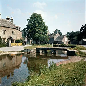
Lower Slaughter WSA01_05_034UP STREAM BRIDGE, BECKY HILL, LOWER SLAUGHTER, COTSWOLD, GLOUCESTERSHIRE. A view from the west of Up Stream Bridge
Kiosk OFH01_01_02_042Clock House, West Hill, East Putney, Wandsworth, Greater London. A man sitting beside a drinks kiosk in front of the Clock House stables
Wandsworth OFH01_01_02_030Wandsworth High Street, Wandsworth, Wandsworth, Greater London. Wandsworth High Street seen from Broomhill Road looking towards numbers 138-144 Wandsworth High Street
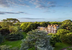
Boston Manor House DP371337Boston Manor House, Boston Manor Park, Brentford, Hounslow, Greater London. Oblique aerial view, taken with a drone, from the south-west
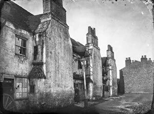
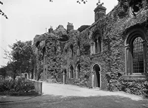
West Front CC78_00232The West Front, Bury St. Edmunds, Abbey Precincts, St. Edmundsbury, Suffolk. An exterior view of the houses which were built into the remains of the west front of the church at Bury St Edmunds Abbey
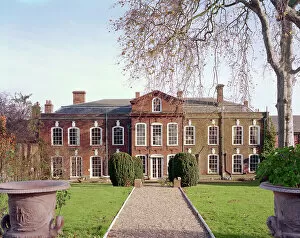
Northgate House BB99_05143Northgate House, 8 Northgate Street, Bury St. Edmunds, St. Edmundsbury, Suffolk. Exterior, West Front View From West